
OtterbergRamstein Air Base · KMC


LEISURE TIME

Good to Know
Good to know
Regional activities
Looking for more events and recreational activities in the region?Ramstein and Kaiserslautern
Download the- CALENDAR OF EVENTS and
- LEISURE & SIGHTS brochure
Palatinate region
You can also visit the official website of the Rheinland-Pfalz Tourism Office to find out more about- Hiking
- Cycling
- Travel Highlights
- Event Highlights
Campsite
Campingplatz „Gänsedell“
In der Gänsedell 1
67697 Otterberg
Short description
The terraced complex is located on a wide forest path in a quiet, sunny south-facing slope and is only a few meters from the beautiful Otterberg.
Terrace area with 3.2 ha
140 parking spaces
15 toilets
1 laundry room
2 wash cabins
10 showers
1 sanitary building
3 sinks
Children's playground
ping pong
washing machine and dryerContact information
Phone: 06301 5537
Email: info@camping-otterberg.de
Cycle route
Course: Enkenbach - Alsenborn - Otterberg - Weilerbach - Niederstaufenbach
Short description
The "Pfälzer Land" cycle path is with its 43 km the east-west connection from the Alsenz at Enkenbach-Alsenborn, through the North Palatinate highlands and thus leads directly through the union community Otterbach-Otterberg, to Niederstaufenbach.
The bike path leads through diverse, varied landscapes and offers good combination possibilities with other cycling tours.
Key data
Distance: 43 km
Ascent: 150 m
Descent: 195 m
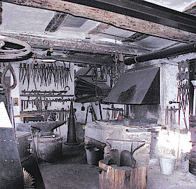
Guided tour through the old smithy
Schmiede Theis
Kirchstr. 15
67697 Otterberg
Time
The old smithy is open to the public at 4 p.m. every first Saturday of the month. Admission is free
Short description
Originally built in 1612 outside the walls of the monastery, this estate has been in the possession of the Theis family for seven generations and was in use as a forge until as recently as 1980. The forge is one of the oldest in the region and has been fully restored as a farrier museum complete with a pair of leather bellows and a solid sandstone forge.
Contact information
Hiking route - 1. Kneipp
Starting point
City Hall
67697 Otterberg
Key data
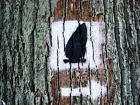
Marking: Black 1 on a white disc
Distance: 9.5 Km (~ 6 miles)
Walking time: approx. 2.5 hours
Difference in altitude: 50 meter (~ 55 yards)
Option for a stop: Restaurants in Otterberg”
Description
From the starting point close to the town hall, which was officially opened in 1990, follow the route along “Lauterer Straße”. The local people call this road “Lautringer Weg”. In the past when people were still going to their workplaces or to the market on foot it was the connecting road to K’town. We follow this route until just before the “Beutlermühle” (Beutler-Mill) where we turn left into “Baumstrasse”. In the past the “Beutlermühle” was known as a deserted settlement by the name “Weiler”. For the first time “Weiler” is mentioned in the foundation document of the Otterberg Monastery from the year 1143, in which the Abbot of Eberbach inter alia “received the benefice of the next located small village”.
After dissolution of the Otterberg Monastery in 1566, the Palatine administrator Engel leased “Weiler” out for 6 years. In 1579 “Hofhaus Weyler” and adjacent buildings were handed to the newly settled Walloon citizens for free. The official Otterberg inventory of 1658 lists for “Capelle zu weyler” the following: 1 chapel, 3 houses, 4 meadows, 1 yard, 1 mill (“Walkmühle”), and some property (“Woog”) in the “Weyler Grund”.
The “Walkmühle” was destroyed during the Thirty Years’ War. After 1707 the Mennonite Christian Beutler purchased and rebuilt the place, which was at that time named the “Alte Walckmühl zu Weyler” including the only old house left close to the street. For a long time the family owned the site and it had been used as a farm and mill until quite recently.
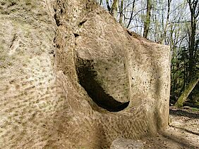
Follow the route to the “Rotenberg” (305 m), named after all the red sand around it. Thereafter you walk downhill the “Götzenwooger Hang” to the valley of “Raupenthal”. Here you find a boundary stone from 1786. This area is named “Götzen-“ or “Kätzenwoog”, which had been the fishing grounds for the monastery. It does not exist any more but is still a very wet area. We continue through a very long and flat plain, Black Forest in the vernacular, until we arrive at “Ultes-Rast”, a recreation area, which invites for a rest. After that we turn left and walk about 800 m uphill to “Weinbrunnerhof”, which is named after a so-called “wine well” in the vicinity. There are different opinions about the origin of this name. Some say that it got the name because it was located close to a wine trail, on which the wine grower transported their wines. Others say that the well is named after the Middle High German word “winne”, which stands for cattle pasture. The “Weinbrunnerhof” was originally a factory for glassworks, which was founded in 1709. Presumably it was closed during the second half of the 18th century due to a decreasing stock of wood. After that until today the “Weinbrunnerhof” has been used for agricultural purposes.
“Haus Hamann”, located at the forest edge of “Weinbrunnerhof”, is a nice hotel and restaurant (closed on Monday). We continue our hike into direction “Althütterhof”. At the fork in the road, opposite the house of Family Stark, you’ll find a very old fruit press. The marking continues along the main road whereas a wonderful trail goes into the same direction on the other side along the edge of the forest. We follow the markings or trail along the “Weinbrunner Valley” until we reach “Althütterhof”.
The name had been derived from an old factory for glassworks, which was located there once. In a report from the 22nd February 1661 it was mentioned for the first time. The Electoral government leased 300 acres beech wood to Mrs von Conde with the obligation to build a factory for glassworks and to pay a rent of 60 guilders per year. This little factory produced beer and wineglasses, goblets and windowpanes without being very successful. During construction works in 1966 workers found leftovers of foundations and glass production tools as proof of this facility. In 1788 this factory ceased to exist, because in a book from this year this place was mentioned now as a farm called “Meierhof”.
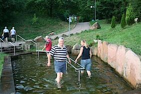
When we continue we see some ponds on the left, which were used for fish farming already during the time of the monastery. When monastery ceased to exist most of the ponds were drained and became meadows. However, you can still see some ponds to the left of the road. At the tennis court of “OTC Mühlwoog” turn left into the “Bachstade” and follow the footpath along the “Mühlenbach”, a man-made stream leading up to the city wall of Otterberg. After just some meters you pass the Kneipp-Facility “im Dreibrunnen”, where you can refresh arms and legs with some cold water. Finally, walk along the idyllic “Bachstade” back to the town hall.
Hiking route - 2. Pavillion
Starting point
Johannis parking lot
67697 Otterberg
Key data
Marking: Black 2 on a white disc
Distance: 5 km (~3.1 miles)
Walking time: approx. 2 hours
Difference in altitude: 300 m (~328 yds)
Option for a stop: Hotel “Badstube”
Description
Warning: Circular Route No 2 involves some extremely steep walks.
We start from the parking lot in Johannisstraße in the town centre of Otterberg. This square used to be the “Stadtweiher (town pond) and served as a retention basin in front of the town wall. Until the end of the twenties of the last century the pond was used for bathing. The pond was backfilled in 1967 and a parking lot was built. We proceed along the Otterbach brook through the pond gardens, which is a greenbelt recreation area near the town. After a couple of hundred metres we see the oil mill (Ölmühle), a former agricultural building with a facility that was used to process oleiferous fruit. Count palatine Johann Casimir authorized the mill to operate as early as 1581. The premises are located at the foot of castle hill (324 metres) (Schlossberg), which has its name from the Otterburg castle that used to be on that hill. In 1143 Siegfried IV von Boyneburg-Nordheim donated the castle to the Cistercian monastery Eberbach in the Rheingau valley (near Wiesbaden). From 1168 to 1254 the abbey church and major parts of the monastery were erected in the Ottertal valley. Apart from the abbey church and chapter house, only some fragments can be found in town today.
A model of the monastery is on exhibition in the museum of local history, which illustrates the dimensions of the original property.
We cross the country road L387 and pass “Hotel Badstube”. In the open space to the right of the valley along the rivulet some horses, geese and ducks are kept. After 200 m (~220 yds) the road leads into the forest where you’ll find a summerhouse on the left side. Follow the marking for route No. 2 and turn left at the fork after about 250 m (~270 yds).
After a long ascent of 1200 m (~1312 yds) we arrive at the “Pavillon”. The “Pavillon” is a hut, which was built by members of Pfälzerwald Association’s local group Otterberg. Here you can take a little rest. If you follow the path approx. 1000 m (~1093 yds) straight ahead you will arrive at a prehistoric menhir, which dates from primitive times.
We turn left and follow the broad path downhill. After about 100 m (~110 yds) you can either turn right onto an unmarked path, which leads to the recreation and parking area “Grafenthalerhof”, or you stay on the broad path and get to the “Heiligenmoscheler Berg” hill after 1200 m (~1312 yds).
Here we hit a fork where we turn left and follow the path for about 300 m (~328 yds). At the barrier you can either make a right turn and follow the path to an open-air forest classroom or follow the marking for route No. 2 and approach a training ground for traffic newcomers. Here young (and old) cyclists and motorists with and without driver’s license can practise their driving skills in simulated road traffic. This is the only place in the whole county to do so.
We follow the path through a forest of sweet chestnut trees and arrive at a war memorial. From here you have a unique panoramic view over Otterberg. Finally, steep stairs and a small path between houses will get you back to the starting point of Kneipp Circular Route No 2.
Hiking route - 3. Wallonen
Starting point
Johannis parking lot
67697 Otterberg
Key data
Marking: Black 3 on a white disc
Distance: 12 km (~7.5 miles)
Walking time: approx. 4 hours
Difference in altitude: 50 meters (~55 yds)
Option for a stop: Restaurant “Wallonenhof”
Description
Kneipp Circular Route No 3 takes you through mixed forest on comfortable roads and paths without any major steep walks.
We start from the parking lot in Johannisstraße in the town centre of Otterberg. This square used to be the “Stadtweiher (town pond) and served as a retention basin in front of the town wall. Until the end of the twenties of the last century the pond was used for bathing. The pond was backfilled in 1967 and a parking lot was built.
We proceed along the Otterbach brook through the pond gardens, which is a greenbelt recreation area near the town. After a couple of hundred metres we see the oil mill (Ölmühle), a former agricultural building with a facility that was used to process oleiferous fruit. Count palatine Johann Casimir authorized the mill to operate as early as 1581. The premises are located at the foot of castle hill (324 metres) (Schlossberg), which has its name from the Otterburg castle that used to be on that hill. To the right we see “Schwarzhübel” hill (342 m - ~374 yds). After 400 m (~437 yds) we reach the sports centre and walk around the swimming pool, which is filled with unchlorinated pure spring water. We proceed along the path between the swimming pool (left) and the restaurant (right) along the “Neumühler Hang” slope through the “Scheid-Wald” forest. This path is also called the “Totenweg” (path of the dead) because all deceased people from the Drehenthaler Hof farm were carried along this path for their funeral at the graveyard. After 2 km (~1.3 miles) at the Drehenthaler Hof farm we cross the road and walk straight ahead onto the forest way.
The route is now marked with the well-known “3” and additionally, with a red dash, a symbol for the international long-distance hiking trail leading from the Donnersberg hill via the Pfalz to French Alsace. After 400 m (~437 yds) we turn right towards Potzbach. 500 m (~547 yds) further down the road, close to marking No 7, we find the so-called “Hünen- or Hügelgräber” (hill graves). These are prehistoric burial mounds. Unfortunately, archaeological excavations are not allowed that might hint at the source, age, or scientific background of these stones formations.
We continue our walk for about 1.8 km (~1.2 miles) until the paths with markings “3” and “red dash” separate again. We turn right and follow the “3” to the western offshoots of the “Einsiedler Berg” hill (370 m / ~404 yds). We pass a picnic area with an oval group of seats, which are dedicated to Oswald Schäffler, a local celebrity. 2.5 km (~1.55 miles) further on we arrive at the “Rabenthal” road, which is part of the “Drehenthaler Hof” farm. The premises are located on the grounds of former glass works dating back to the early 18th century and that ceased to exist in the middle of the 19th century. Today, about 400 people live in the area which is predominatly used as farmland. From a fountain structure in the centre of the village we continue along a road called “Glashütter Straße”. After 750 m (~820 yds) a small road to the left leads to a very popular barbecue area.
Behind the cemetery, we follow the path just beside the main road, which we used earlier. The marking “3” guides us to the elevated hiking trail via the “Schweisberg” hill (334 m, ~365 yds). After 250 m (~237 yds) on the other side of the main road in the “Fuchsbrunner Wald” forest a fairground is located, where the people of Otterberg celebrate their traditional spring festival every two years (in odd years only). After another 250 m a stone quarry is located to the left. The building blocks for the memorial on the “Heiligenmoscheler Berg” hill were taken from here in 1933. It is one of five stone quarries, which are still operated around Otterberg.
The adjacent flood plain is the source of water supply for the area (pumping station) and the source of the Otterbach brook, which actually comes from the “Otter spring” at the “Scheidwald” hill (363 m, ~397 yds).
We can also see the “Neumühle” residential building, which was a flour mill in former times. Until 1960 the “Lohmühle” mill was located slightly above; the works produced tanning agents for the numerous tanneries in Otterberg.
After walking past the pump station we walk through the “Otter” valley. This idyllic path lined with very old trees, takes us back to the starting point in Otterberg via the swimming pool.
Hiking route - 4. Appental
Starting point
City Hall
67697 Otterberg
Key data
Marking: Black 4 on a white disc
Distance: 11 km (~6.8 miles)
Walking time: approx. 4 hours
Difference in altitude: 100 meters (~110 yds)
Description
Kneipp Circular Route No 4 is an easy walk without any major slopes. There might be some wet spots just after the start of the walk.
From the starting point close to the town hall, which was officially opened in 1990, follow the route along “Lauterer Straße”. The local people call this road “Lautringer Weg”. In the past when people were still going to their workplaces or to the market on foot it was the connecting road to K’town. We follow this route until just before the “Beutlermühle” (Beutler-Mill) where we turn left into “Baumstrasse”. In the past the “Beutlermühle” was known as a deserted settlement by the name “Weiler”. For the first time “Weiler” is mentioned in the foundation document of the Otterberg Monastery from the year 1143, in which the Abbot of Eberbach inter alia “received the benefice of the next located small village”. A document from 1195 certifies that “Wilre” alias “Weiler” is owned by the monastery and, later on, Pope Innozenz III. confirmed the title in 1215. The privilege to do timber work by the monastery and the farmyards “Schwanden” and “Weiler” in the forests of “Waltmark and Brant” was granted in 1275 and again documented in 1324.
After the Otterberg monastery was disbanded, the Palatine administrator Engel leased “Weiler” in 1566 for 6 years. In 1579 “Hofhaus Weyler” and the adjacent buildings were handed to the newly settled Walloon citizens for free. The official Otterberg inventory of 1658 lists for “Capelle zu Weyler” the following: 1 chapel, 3 houses, 4 meadows, 1 yard, 1 mill (“Walkmühle”), and some property (“Woog”) in the “Weyler Grund”.
The “Walkmühle” mill was destroyed during the Thirty Years’ War. After 1707 the Mennonite Christian Beutler purchased and rebuilt the place, which was at that time named “the Alte Walckmühl zu Weyler” including the only old house left close to the street. For a long time the family owned the site and it had been used as a farm and mill until quite recently.
Follow the route to the “Rotenberg” hill (305 m, ~334 yds), named after all the red sand around it. In the beginning the path might be very soaked and not easy to walk along. At the intersection point after about 1 km (~0.62 miles) we walk straight ahead following the marking sign “No 4” only. To the right we see a path marked “No 1 and 4”, which will be our way back; to the left we have the route to “Althütterhof” which is marked with a blue and yellow dash.
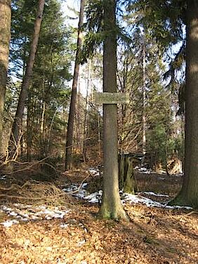
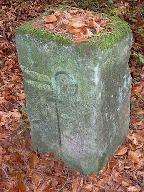
After 100 m (~109 yds) a landmark on the left side shows an abbey crook with the date 1786. After another 500 m (~546 yds) we reach an elevation of 301 m (~330 yds) on top of the “Pfifferlingsberg” or chanterelle hill. More landmarks with the above signs follow after 150 m (~160 yds) each.
At the next road junction after approx. 1 km (~0.62 miles) turn right and follow the marking “No 1, 4, and red dash”. After 200 m (~218 yds) you come to “Ultes Rast”, a rest area consisting of two tables and four benches named after a former lumberjack.
Thereafter, turn left and follow the route marked “No 4”. The path will make a slight right turn and proceed downhill after about 200 m (~218 yds) and has a sandy and soft surface now. Along the path there is another landmark and after a light slope of approx. 500 m (~546 yds) we’ll find a bench for a little rest.
Follow the route, which will turn right after 200 m (~218 yds). Stay on this track with a solid surface to the “Hundskopf” hill (361 m, ~395 yds), where you see the water reservoir for the community of Erlenbach.
After another 100 m (~109 yds) we pass the so-called “Franzens Bank” bench, another rest area, and walk downhill into the “Raupenthal” (valley of caterpillars). There is another landmark next to the path. The next 400 m (~436 yds) you walk over soft forest soil, followed by a 300 m (~328 yds) sloping downward on a loose gravel path. There are some anthills at the wayside. Shortly after that, at the “Götzenwooger Hang” slope, route 4 and 1 come together once more. Now the path is leads uphill to the “Rotenberg” hill again, where we hit fork. Here another bench invites you for a rest.
From here follow the well-known route “No 1 and 4” back to the starting point in Otterberg via the “Rotenberg” hill.
Hiking route - 5. Quellen
Starting point
Johannis parking lot
67697 Otterberg
Key data
Marking: Black 5 on a white disc
Distance: 6 Km (~ 4 miles)
Walking time: approx. 3 hours
Difference in altitude: 200 meter (~ 220 yards)
Option for a stop: Hotel “Badstube”
Description
Except for one particular incline the hiking trail leads along easy roads and paths, which are partly quite overgrown, almost exclusively through mixed woodlands.
We start from the parking lot in Johannisstraße in the town centre of Otterberg. This square used to be the “Stadtweiher (town pond) and served as a retention basin in front of the town wall. Until the end of the twenties of the last century the pond was used for bathing. However, the former function as a retention basin was only realised when the pond was backfilled in 1967 and a parking lot was built. We proceed along the Otterbach brook through the pond gardens, which is a greenbelt recreation area near the town. After a couple of hundred metres we see the oil mill, a former agricultural building with a facility that was used to process oleiferous fruit. The mill had been operated from as early as Michaelmas (i.e. 29 September) in 1581, approved by Count Palatine Johann Casimir. The premises are located at the foot of castle hill (324 metres), which has its name from the Otterburg castle that used to be on that hill. In 1143 Siegfried IV von Boyneburg-Nordheim donated the castle to the Cistercian monastery Eberbach in the Rheingau valley (near Wiesbaden). From 1168 to 1254 the abbey church and major parts of the monastery were erected in the Ottertal valley. Apart from the abbey church and chapter house, only some fragments can be found in town today.
Change:
We continue along the local signposts 5 and 3 until we reach the new water works. Here we turn right and then, just behind the water works, left again towards the sports centre. After about 500 metres we see the oil mill, a former agricultural building with a facility that was used to process oleiferous fruit. The mill had been operated from as early as Michaelmas (i.e. 29 September) in 1581, approved by Count Palatine Johann Casimir.
The premises are located at the foot of castle hill (324 metres) with the Schwarzhübel hill (342 metres) to its right. We arrive at the sports centre after some 400 metres and walk around the outdoor swimming pool. The pool is operated on source water with no chlorine additives. The swimming pool restaurant is in front of us to the right with the pool to the left. We carry on for some 200 metres on the access road to the swimming pool. We cross country road L 387 road and continue our hike on the service road up to the access of the camping site. The campsite “Gänsedell” is open to both resident campers and holiday campers. At the parking lot near the entrance to the campsite hiking path 5 takes us to a small staircase on to the adjacent sloping forest path away from the country road. After a 1 km walk we arrive at the source at the Kohl-Dell located near a sunny road that takes us to the Birotshof farm.
The Birotshof farm was built by the local Otterberg butcher David Piroth (1689-1743) near the Kiefernbrunnen well, where some masonry remnants of the original farm were found as late as in the 20th century. Today there is only a signpost reminding us of the original location of the farm. After many new constructions and alterations the present buildings are only used for residential purposes.
The path takes us to the left onto a heavily overgrown path, which takes us across the Badstuber Hübel hill (357 metres) into the Schellental valley. After some 2 kms we arrive at the memorial stone for the forest worker Herbrand. This stone marks a water source that feeds a brook running alongside our path up to the country road L 387. Here the path makes a left turn and we cross the moist Schellental valley until we arrive at the country road.
In the Hotel Badstube we can sit down and have a break.
At the road we rejoin the path that we took as we started, and we walk back through the greenbelt recreational area and the former pond until we reach at our starting point.
Hiking route - 6. Zisterzienser
Starting point
Johannis parking lot
67697 Otterberg
Key data
Marking: Black 6 on a white disc
Distance: 10 Km (~ 7.5 miles)
Walking time: approx. 2.5 hours
Difference in altitude: 350 meter (~ 380 yards)
Option for a stop: “Haus Schippke”
Description
The path includes major inclines and walking is difficult in some parts.
Starting at the parking lot in Johannisstraße we walk along the old town wall toward the cemetery. Until 1561, when the monastery was disbanded, the cemetery was located inside the area surrounded by the town wall north of the church. After Walloons settled in 1579, a new “graveyard was established at the present location outside the town wall. The path goes uphill to the Schlossberg hill (324 metres), where the core of the Otterberg settlement –Otterburg castle – was located. In 1143 Siegfried IV von Boyneburg-Nordheim donated the castle to the Cistercian monastery Eberbach in the Rheingau valley (near Wiesbaden). “In the name of the holy and indivisible trinity. Be it known to all future and present, that I, Heinrich, by the divine mercy Archbishop at Mainz, willing to support the pious efforts of the abbot of Eberbach, have conveyed the church inside the old Otterburg castle as well as the prebend of the church in the nearby village including altarpieces and tithing and the synodal taxes I am entitled to, so he shall establish a monastery there …” this is the wording of the corporate charter of the monastery prepared by Heinrich von Wartburg in Mainz in 1143.
If we took a left turn leaving the signposted path at the top of the Schlossberg hill near the small birch grove, we could walk over to the Otterberg high-level water tank. This is located right inside the former castle grounds. Unfortunately apart from the moat and a wall, there are no remnants of the castle left on the surface. The path forks up on the Schlossberg hill. In front of us we see a private animal enclosure; we take the right fork and walk on across the Frohnberg hill. After about 1 km we arrive at the L 383 country road towards Baalborn. After another 1,000 metres we arrive at an old water house. This little building holds a well that was used for the fresh water supply for the nearby Münchschwanderhof farm. From the edge of the forest we can see this farm on the opposite side of the road.
The settlement came under the Otterberg monastery in 1195 and had since been listed as a Grangie, i.e. an external granary, in historic documents. Early in the 16th century the monastery farm went to ruin because of looting and pillaging during the Peasants’ War (in 1525).
In the Otterberg capitulation dated 15 June 1679, Count Palatine Johann Casimir expressed his intention of creating settlements for the Walloons in the unused buildings of the former monastery. The first hereditary tenants were Peter Carra and Claus Olivier who took over Münchschwanderhof in 1579. During the 17th and 18th centuries more peasants settled at the Münchschwanderhof, which gradually became a farm settlement.
At the waterhouse, we cross the red line marking and walk into a tract of forest. After about 1 km, we turn left towards the Lanzenbrunner Weiher pond; the path, however, does not go directly along the edge of the pond, which is one of the last preserved fishing ponds of the Otterberg monastery. The monks actually did without meat, but they were allowed to eat fish. Therefore they established numerous ponds in the valley pastures and used them for fish farming. What used to be known as the Krömmel- or Kümmelwoog pond should be identical to today’s Lanzenbrunner Weiher pond. District names such as “Lantzenprunnen” (1600), “Lengstall” (1731) and “Lanzendäll” (1800) can be found in historic documents. It is assumed that the original name stems from Middle High German “langez” and/or “lenze”. Both forms refer to the modern German word of Lenz, which is another expression for spring. Consequently the “Lanzenbrunnen” would be translated as “spring source”, meaning a source that would bubble up stronger when spring arrives.
The tenant of shoot Dr. Karl Ritter bought Lanzenbrunner Weiher in 1903 and had a hunting lodge built in 1904. It is not know if there had been any earlier construction in the area. The Ritter family from Kaiserslautern own the place still today; however the farm has been leased to tenants and is used for agricultural purposes.
After some 500 metres we turn right into a path that leads along the edge of the forest. After 250 metres we take the path that leads into the forest and after 250 metres we join the path of the red line marking. The path leads through a ravine, which is quite difficult to negotiate. We turn left at the end of the ravine. After 100 metres we cross the “Nabinger Weg” path, named after the forest warden Nabinger. We follow the slope towards großer Ohligskopf hill (377 metres). After 750 metres we walk downhill into the valley, where we arrive at the source of the Otterberg freshwater supply. We walk up again to Schlossberg hill to take the same way back to the parking lot. On our way we can have a rest in the Pension Schippke, a boarding house closed on Fridays!
Motorcycle Museum Otterbach
Motorrad Museum Otterbach
Otterstraße 4
67731 Otterbach
Short description
Since 1980 the Motorcycle Musuem Heinz Luthringshauser is hosting an unique permament exhibiton about historically important motorcycles in rooms that – used for that purpose - you can’t find anywhere else in the world. The exhibition is housed in the protestant church of the town.
Opening hours
April – October:
Sundays and public holidays: 10 am - 12.30 pm & 1.30 - 5 pm
If you want to visit outside of these hours contact: 06301 23 67
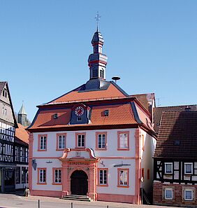
Museum Otterberg
Museum Otterberg
Hauptstraße 54
67697 Otterberg
Short description
The Baroque building in the old "city house" was built in 1753. The year in roman numerals (MDCCLIII) is carved on the portal.
In the baroque tower hangs a bell from 1742, which was rung case of fire. Today, the museum containing exhibits on findings from the monastic and Walloon periods, as well as the history of the city of Otterberg is housed here. The tourist information office is also located here.
Opening hours
Mon. - Fri.: 9 a.m. - 1 p.m. & 2 - 5 p.m.
Wed.: 9 a.m. - 1 p.m.
Sun.: 3 - 5 p.m.
Apr. - Oct. also on
Sat.: 9.30 a.m. - 12.30 p.m.
Sun.: 3 p.m. - 5 p.m.
Contact information
Phone: 06301 3630
Natural outdoor pool
Naturfreibad Otterberg
Schwimmbad
67697 Otterberg
Short description
The natural outdoor pool contains pure spring water without any chemical substances. A generous water surface of approximately 5000 square meters awaits you.
Contact information
Phone: 06301 7185682
Network of hiking trails
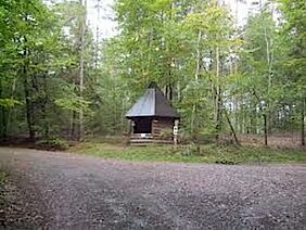
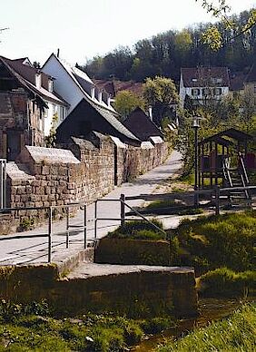
The forests around Otterberg have a mixture of various types of trees and are inviting places to enjoy a robust hike or leisurely stroll. There are rest stations with outdoor grill facilities that also serve as departure points for hiking tours of the area.
Walks among the rolling hills constantly reveals new scenes of nature and the ecology. Distance markers show the way for many the different hiking routes crisscrossing the countryside and forest. You can follow a single route, or combine parts of many routes to create a tour tailored to your own interests. These are the marked hiking routes or Rundwanderwege you will find on this page.
Premium hiking route - Devil's Tour
Starting point
Train station in Olsbrücken
67737 Frankelbach
Key data
Distance: 14.9 km
Duration: 4:23 h
Ascent: 383 m
Descent: 382 m
Description
The slogan for the tour keeps its promise: devilish climbs and heavenly prospects. The 15 km premium trail "Teufelstour" takes its name from the Teufelstein, a former Roman quarry in Frankelbach. Geological highlights are explained on several information boards. A special feature: This path leads directly through the stone quarry of Sulzbachtal.
Supported by 1. FCK, (the local soccer club) the path was signposted using the devil’s emblem from the FCK’s stadium Betzenberg.
The mix of wild and romantic river valleys, steep climbs and a breathtaking view over the Palatine Uplands and the Palatinate Forest right up to the Donnersberg, makes the “devil’s tour” with its 15 km total length into a unique discovery tour of the Palatinate.
On narrow paths and trails which have hardly changed in the course of time we have the opportunity of passing through almost 300 million years of geological history. Passing both old and still active stone quarries, ambitious hikers can inform themselves on several geological information boards set up by the State Office for Geology and Mining.
For active recreation whilst hiking you should not forget to stop and take a break. Along the Teufelstour you will find many beautiful places to rest and linger. The Panorama-Gasthof Emmerwiesenhof in Eulenbis , for example, is situated directly on this premium hiking trail.
In "Fossils worldwide", Hebelstraße 4 in Sulzbachtal the geological subsoil can actually be felt. This exhibition is constructed as both a sales and museum vicinity. A wide range of minerals and fossils, which partly come from the immediate vicinity of the Sulzbachtal , are on display.
Contact information for a guided tour
Hiking leader of the union community Otterbach-Otterberg:
Mario Marx
Phone: 0157 36790509 or 06308 1358
Email: marimarx@web.de
Premium hiking route - Hinkelsteinweg
Starting point
Drehenthalerhof
67697 Otterberg
Key data
Distance: 40.5 km
Duration: 10:45 hours
Ascent: 655 m
Descent: 655 m
Description
The Hinkelstein, a prehistoric monolith, and the fields of mound graves as well at the old high streets bear witness to the old settlements from thousands of years ago in this area. To the Northwest the forest thins and reveals the view over the North Pfalz hill country with its farm fields and meadows.
From the Drehenthalerhof (from both directions), it is possible to hike along the Hinkelsteinweg in two stages (20 km and 23 km).
The Hinkelsteinweg starts at the Abbey Church in Otterberg, which, after the Speyer Cathedral, is the largest church in the Palatinate. We follow the trail markers (gray menhir stones on a white background) through the historic old town, past beautiful, half-timbered houses. Having reached the town walls, we turn left and then again immediately right and, after a short distance along the Lauterstraße, head left into the Bachstade. Following the trail, we reach a paved road after the Kneippanlage, on which we turn to the right. Continuously uphill, the trail leads along the Johann-Roos-Straße and then to the Rotenberg where we turn left in the forest. We follow the trail marker "black menhir on a white background" over the Pfifferlingsberg and past the "Mehlinger Heide", one of the largest heathlands in southern Germany. And well worth a visit especially in August, when the heather is in full bloom. A sign takes you to the entrance.
Through the forest we follow the path and reach the idyllic Weinbrunnerhof. After a short stretch on the paved road, we turn right onto a natural forest path which, at the upper end, gives us our first views of the Palatinate highlands. We cross the L 382 and wander on natural pathways to the Lanzenbrunner Weiher, a gem of the Otterberger forest. We now walk through the valley of the Grafenthaler brook, past the Husarenbrunnen, until we reach the signpost at the Drehenthalerhof. Here it is possible to shorten the trail and take the loop trail back to Otterberg.
We follow the trail markers on the Kahlenberg to a small quarry where the rare Leopard sandstone used to be extracted. A magnificent view for Donnersberg awaits us on the hill in front of Potzbach. We walk through Potzbach, open landscapes then accompany us past the Leithöfen and reach again a deciduous forest which accompanies us until we reach the "Igelborner Hütte" - a forest tavern run by the Pfälzerwald-Verein Ortsgruppe Winnweiler (opening times: Wed from 11:30 hrs.; Sat from 14:00 hrs.; Sundays / holidays from 10:00 hrs.; For groups of 10 people or more, following reservation). From here it is possible to connect to the "Pfälzer Höhenweg" at the Winnweiler Bahnhof. You should follow the trail marker "black menhir on a yellow background ''.
The path now leads downhill to Höringen where the Bauerncafe Gebhardt (opening times: only for (hiking) groups by appointment, Tel. 06302-1231) invites you to stay longer than planned with its delicious food . We then go uphill, over the Hauptstrasse, Bergstrasse and a meadow path before we are rewarded for our efforts with a magnificent view over to the Donnersberg , the highest hill in the Palatinate, with its 687 metres.
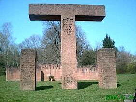
On the following stage of the Hinkelsteinweg we encounter a variety of landmarks, which, if they could talk, would tell you more about the history of the Otterberg Monastery. The crozier is still recognizable on many of the surrounding stones. Now we reach the menhir "Hinkelstein", which gives the trail its name.
Menhir was originally a Breton name meaning long stone for a stone monolith set up vertically and several metres in height (maen = stone, hir = long). In German-speaking countries menhirs have been called “Hinkelstein” since the Middle Ages.
At the menir "Hinkelstein" the regimes of the Falkenstein, Kurpfalz and Schallodenbach met up with each other until the French Revolution. Even today, the massive “Hinkelstein” is the border stone where the municipalities of Otterberg, Höringen and Heiligenmoschel meet. The Hinkelstein was first mentioned in the year 891 by the Romans and is still about 2.20 metres high and 1.50 metres wide and is flanked by two carved boundary stones. A seating area invites you to rest .
Further along on our way, we pass the Lenhardt-Stein, a memorial stone for a former ranger, turn off at the pavilion and walk downhill to Birotshof, where we will find an enchanted pond. Further down we cross the L 387 and get to the festival site of the historic Spring Festival (held in years with an odd number) of the town of Otterberg. Now we go uphill again to the Drehenthalerhof where there is a shortcut towards Winnweiler.
Down through the Scheid-Wald, we walk through the flood plains of the Otterbach to the town of Otterberg, with its beautifully-situated natural swimming pool. Further along the flood plains we come to the Johannis parking lot. We cross the parking lot and the Johannisstrasse, go through the “Loch" (a passage between the houses at the Gaststätte Kraus) into the old town of Otterberg and back to the starting point of this circular route, the abbey church.
Contact information
Tourist-Information, Union community Otterbach-Otterberg
Hauptstr. 54, 67697 Otterberg
Phone: 06301 31504
Rent the barbecue hut in Drehentalerhof
Grillplatz Drehentalerhof
67697 Otterberg
Short description
On the Drehenthalerhof is a rentable barbecue area with toilet facilities and a covered fireplace. The place can be rented during the summer months.
Contact information
Phone: 06301 607413
Theis Forge
Schmiede Theis
Kirchstr. 15
67697 Otterberg
Short description
Originally built in 1612 outside the walls of the monastery, this estate has been in the possession of the Theis family for seven generations and was in use as a forge until as recently as 1980. The forge is one of the oldest in the region and has been fully restored as a farrier museum complete with a pair of leather bellows and a solid sandstone forge.
It is open to the public on the first Saturday of the month at 3 p.m.
Contact information
Traffic training area
Verkehrsübungsplatz
Heiligenmoschelerberg 3
67697 Otterberg
Short description
Here you can learn how to drive if you don't have a driver's license yet.
The use of the area is allowed for cars, motorcycles, moped, as well as for traffic lessons.
Within the fenced off area, young people who are at least 14 (moped, moped, moped),15 (car) or 16 (motorcycle) can learn how to drive, but not yet have obtained the required permission. The vehicle owner must be present with a driver's license as a companion or sit next to the trainee.
Contact information
AVIA Gas station Otterberg
Hauptstraße 2
67697 Otterberg
Phone: 06301 9518